The map below roughly estimates our nation’s population density in 1775. It also gives insight into where those populations were centered. Larger populations consumed more beer and liquor, so brewers and distillers would have been kept busy! This map becomes a good way to illustrate early American whiskey history by showing not just where the people were, but where the drinkers were!
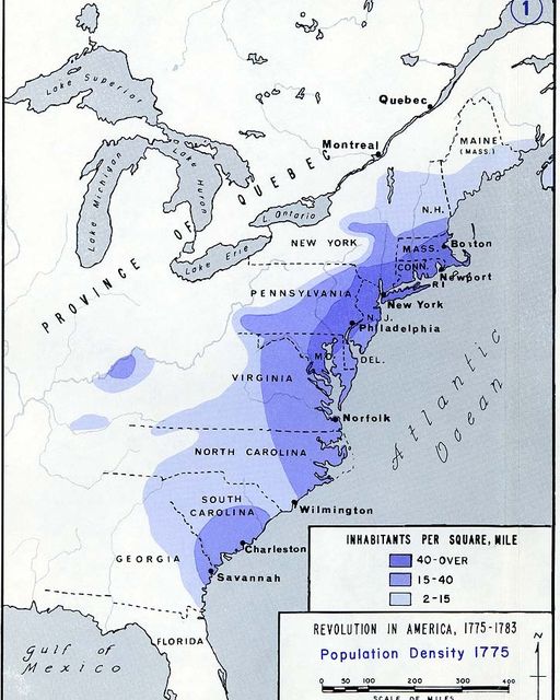
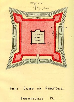
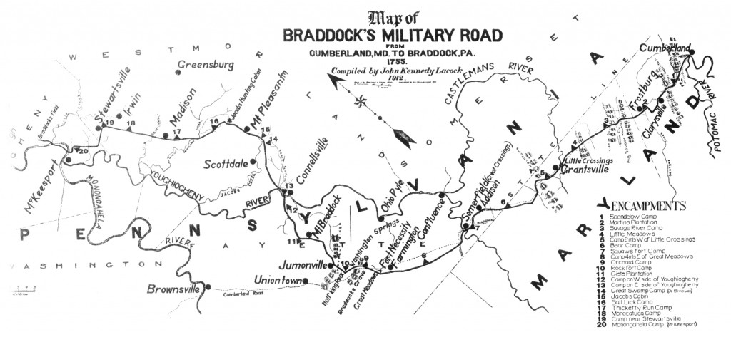
Note the largest populations center around the coastal northeast (Boston, New York, Philadelphia, etc.). Westward expansion was happening in Pennsylvania, but along military routes like “Braddock’s Road”, the old “Nemocolin Trail” (Cumberland Trail), and “General Forbes’ Road”. Immigrants were moving along routes that were protected by newly established military forts. The dark blue “finger” on the map that’s pointing west across Pennsylvania points to the site of old Redstone Fort (Brownsville, Pennsylvania)- to where the fort sat beside the Monongahela River. Brownsville, Pennsylvania was the terminus of a major wagon route used by immigrant settlers traveling west through the colony. From there, going further west meant traveling by boat. All that traffic made Brownsville a major boatbuilding site and a bustling center of commerce. The surrounding valley became famous for its rye whiskey- “Old Monongahela” rye whiskey, to be exact. “And what’s that other darker blue splotch further west” you ask? That’s the population centered around Louisville, Kentucky! “And how were the settlers getting there?” By taking boats from Brownsville in Pennsylvania, of course!
A traveler or tradesman in the 1760s and 70s could move north from Fort Redstone in Brownsville to Fort Pitt (previously Fort Duquesne) along the Monongahela River (“The Mon” flows north!). From there, they could head west along the Ohio River until the Falls of the Ohio halted their progress at Louisville. Louisville and southern Indiana became important trade locations, and the thirsty inhabitants living there would soon begin their own brewing and distilling traditions. The other lighter blue spot out west? That’s Nashville, folks. Both Louisville and Nashville were important traders in salt- that all important necessity (food preservation, hunting and fur trade, etc.) that was often traded for whiskey! And if they were drinking whiskey, you can be sure it was rye whiskey Some of the earliest mentions of “Old Monongahela” rye whiskeys were in Nashville’s newspapers. The largest consumers of Western Pennsylvania’s rye whiskeys, believe it or not, were southerners. That would continue to be the case well after the Civil War, too.
One more interesting thing to note is that the Mississippi does not play a large role in whiskey history in 1775. That trade route was closed off to the colonies by the French and the Spanish until several years later. The negotiations that opened trade and the invention of steamboats would change things quite a bit in the years that followed. But until then, this map lays it out pretty well!